
Fail:NUTS 2 statistical regions of the United Kingdom map.svg

Saiz pratonton PNG bagi fail SVG ini: 405 × 599 piksel . Leraian-leraian lain: 162 × 240 piksel | 324 × 480 piksel | 519 × 768 piksel | 692 × 1,024 piksel | 1,384 × 2,048 piksel | 871 × 1,289 piksel.
Fail asli (Fail SVG, ukuran dasar 871 × 1,289 piksel, saiz fail: 3.33 MB)
Ringkasan
| Keterangan |
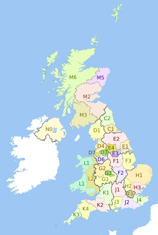
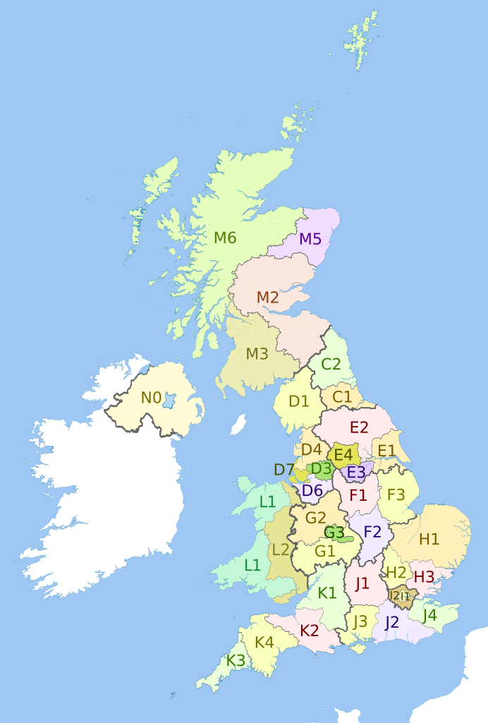
English: Map showing the NUTS 2 statistical regions of the United Kingdom in 2011.
Equirectangular map projection on WGS 84 datum, with N/S stretched 170% Geographic limits:
|
| Tarikh | (UTC) |
| Sumber |
This file was derived from: |
| Pengarang |
|


Perlesenan
Fail ini dilesenkan di bawah lesen Pengiktirafan-Perkongsian Serupa 3.0 Tidak Diport Creative Commons.
Pengiktirafan: Dr Greg, Nilfanion, NordNordWest & XrysD. Contains Ordnance Survey data © Crown copyright and database right 2011
- Anda bebas:
- untuk berkongsi – untuk menyalin, mengedar dan memindah hasil kerja
- untuk mencampur semula – untuk menyesuaikan karya
- Di bawah syarat berikut:
- pengiktirafan – Anda mesti memberi penghargaan yang berpatutan, bekalkan pautan ke lesen, dan tunjukkan jika perubahan telah dibuat. Anda boleh lakukannya dalam sebarang cara yang munasabah, tetapi bukan dalam sebarang cara yang mencadangkan pemberi lesen mengendors anda atau penggunaan anda.
- perkongsian serupa – Jika anda mengubah, adun semula, atau menokok tambah bahan, anda mesti menyebarkan sumbangan anda di bawah lesen yang sama atau serasi dengan yang asal.
Log muat naik asal
This image is a derivative work of the following images:
- File:United_Kingdom_police_areas_map.svg licensed with Cc-by-sa-3.0
- 2011-10-12T11:33:39Z Nilfanion 871x1289 (2511111 Bytes) {{Information |Description=Map showing the [[w:Police areas|Police areas]] of the United Kingdom in 2011. Equirectangular map projection on WGS 84 datum, with N/S stretched 170% Geographic limits: *West: 11.0W *East: 2.2E *
- File:English_metropolitan_and_non-metropolitan_counties_2010.svg licensed with Cc-by-sa-3.0, GFDL
- 2010-11-23T22:01:59Z Nilfanion 1108x1345 (340057 Bytes) England only
- 2010-11-23T22:00:28Z Nilfanion 1108x1345 (376231 Bytes) {{Information |Description=Map showing the [[w:Metropolitan and non-metropolitan counties of England|Metropolitan and non-metropolitan counties of England]], in 2010. Equirectangular map projection on WGS 84 datum, with N/S
- File:Wales_location_map.svg licensed with Cc-by-sa-3.0
- 2009-06-24T13:27:54Z NordNordWest 1047x1252 (242334 Bytes) {{Information |Description= {{de|Positionskarte von [[:de:Wales|Wales]], [[:de:Vereinigtes Königreich|Vereinigtes Königreich]]}} Quadratische Plattkarte, N-S-Streckung 163 %. Geographische Begrenzung der Karte: * N: 53.5°
- File:Scottish_council_areas_2011.svg licensed with Cc-by-sa-3.0
- 2011-05-01T19:21:40Z Nilfanion 1023x1345 (3008417 Bytes) {{Information |Description=Map showing the [[w:Council areas of Scotland|Council areas of Scotland]] in 2011. Equirectangular map projection on WGS 84 datum, with N/S stretched 170% Geographic limits: *West: 8.8W *East: 0.4
- File:Scotland_Administrative_Map_1947.png licensed with Cc-by-sa-3.0-migrated, FAL, GFDL
- 2009-06-14T12:39:08Z XrysD 2000x3479 (2679270 Bytes) Corrected typo
- 2009-06-14T12:04:54Z XrysD 2000x3479 (2679081 Bytes) {{Information |Description={{en|1=Administrative map of Scotland in 1947. Showing Counties and Districts, Counties of Cities, Large and Smal Burghs}} |Source=Own work by uploader |Author=[[User:XrysD|XrysD]] |Date=2009-06-14
Uploaded with derivativeFX
Sejarah fail
Klik pada tarikh/waktu untuk melihat rupa fail tersebut pada waktu itu.
| Tarikh/Waktu | Gambar kenit | Ukuran | Pengguna | Komen | |
|---|---|---|---|---|---|
| semasa | 21:27, 6 September 2012 | | 871 × 1,289 (3.33 MB) | Dr Greg | Updated with 2010 changes: D2 replaced by D6, D5 replaced by D7 |
| 22:58, 27 Julai 2012 |  | 871 × 1,289 (3.33 MB) | Dr Greg | == {{int:filedesc}} == {{Information |Description={{en|Map showing the en:NUTS 2 statistical regions of the United Kingdom in 2011. Equirectangular map projection on WGS 84 datum, with N/S stretched 170% Geographic limits: *West: 11.0W *Eas... |
Penggunaan fail
Tiada laman yang menggunakan fail ini.